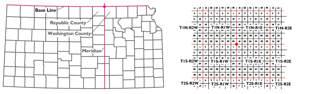
Left: The dot is the location of the 6th Principal IP in relation to the state of Kansas. Right: The red dot represents the IP. Each red square is a geographical Township - not to be confused with political townships. Each Township is identified by the number of Townships from the IP and by the direction from the IP. Each Township is divided into 36 Sections 1 mile on a side and numbered as shown. The Section just southwest of the IP would be identified as T1S R1E S6 (Township 1 South Range 1 East Section 6).
Then the real work began. Manners surveyed Nebraska and Ledlie surveyed Kansas. From the IP, they marked the land in
squares measuring six miles by six miles. Each 36-square mile "chunk" is designated by how far it is from the IP.
Manhattan, Kansas, is mainly located in Township 10 South and Range 8 East. That means it is in the square of land whose
northwest corner is 60 miles south and 48 miles east of the IP.
Each square is then subdivided into 36 one-square-mile units called Sections. The tier of the six northernmost Sections
are numbered from 1 in the northeast corner proceeding westward to number 6. The six immediately below are Sections
7 through 12, but are numbered from west to east. This zig-zag numbering scheme is repeated with the last, Section 36,
being located in the southeast corner.
Each Section of 640 acres is then surveyed into quarters containing nominally 160 acres. Those are then further divided
into quarters containing nominally 40 acres.
Because the earth isn't flat and because surveyors make mistakes, these Townships contains 36 square miles "more or less."
If errors are later discovered, they are only noted for future reference. No one is asked to move their farm or home
because of a surveying error.
These basic land units can be further divided or combined and then portioned into plats which can be divided in any
fashion.
So how was the IP marked in 1856? With a rock - the rock that is now in the manhole. On the east side of the gravel
road laid on the 6th Principal Meridian is a small modern memorial to its setting.
Later, when we were home, I dropped a line to Gloria Moore at the economic development agency of Washington County,
asking how many visitors they have in a year. She replied:
Being a native of Washington County and growing up on a farm, I appreciate the scenery, farmland and valley that surrounds the 6th PM. ... An estimate would be between 250 and 350 visitors per year. The Surveyors from the States of Kansas and Nebraska hold meetings in the area due to the 6th PM and are very proud of the historical significance of the location.
Today, surveying relies on electronic devices, both on the earth and in space, and is unlikely to involve hostile natives. But
in 1856, establishing the 6th IP was an arduous task. So while we enjoyed our visit to the small monument on the open plains,
I believe the work of surveyors Lee, Manners, Ledlie and those who aided them is best recognized by the fact that the legal
land descriptions in those five states, from that claimed by those early settlers on down to the present, still rest on
their work.
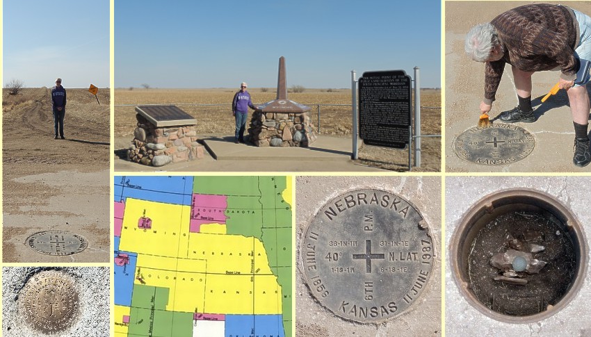
Clockwise from the top left: (1) Manhole in the foreground with Gloria facing east at the end of the rutted country road. (2) Gloria facing west at the memorials for the 6th P.M. IP. (3) Art cleaning the manhole cover of the accumulated gravel. (4) The rock beneath the cover that was set to mark the IP. (5) Manhole cover. Note the Section, Town and Range designation for each of the first four Townships. (6) The yellow area in the five states was surveyed from the 6th IP. (7) Near the IP are several "witness" markers such as this one that can be used to relocated the IP if need be. Photo 4 and some of the information is from articles by Nebraska surveyor Jerry Penry. Photo 6 from Wikipedia.
Comments? [email protected].
Other columns from this year may be found at: Current Year Index.
Links to previous years are on the home page: Home