Kansas Snapshots by Gloria Freeland - April 18, 2014
Playing hooky
"OK, we'll continue south until we reach 12th Street. Then east until we see Quail Road. Rainbow will be the next
one. We turn right on it and go to where it ends."
Husband Art was describing the route he planned to take to Hannibal, a now largely-vanished community in rural
Clay County, Kansas. Last May, my News and Feature Writing students wrote stories about it and nine other places in
the county. As time permits, Art has helped fact-check them before I send them on to the Clay Center newspaper. Part
of that process has been for us to visit the various communities to make certain any iconic photo opportunities haven't
been overlooked.
Since the east-west county streets are one mile apart and Clay Center is divided by 18th Street, we would be about
six miles south of the city. We discovered 12th Street was paved, but Rainbow wasn't. It didn't even appear to be
graveled. I grew up in rural Kansas and am accustomed to unpaved roads. But Rainbow made me uneasy as it looked damp.
In the springtime, more than a few people have required the help of a tractor to be pulled from a muddy Kansas byway.
Fortunately, the surface proved to be quite hard and we had no difficulties.
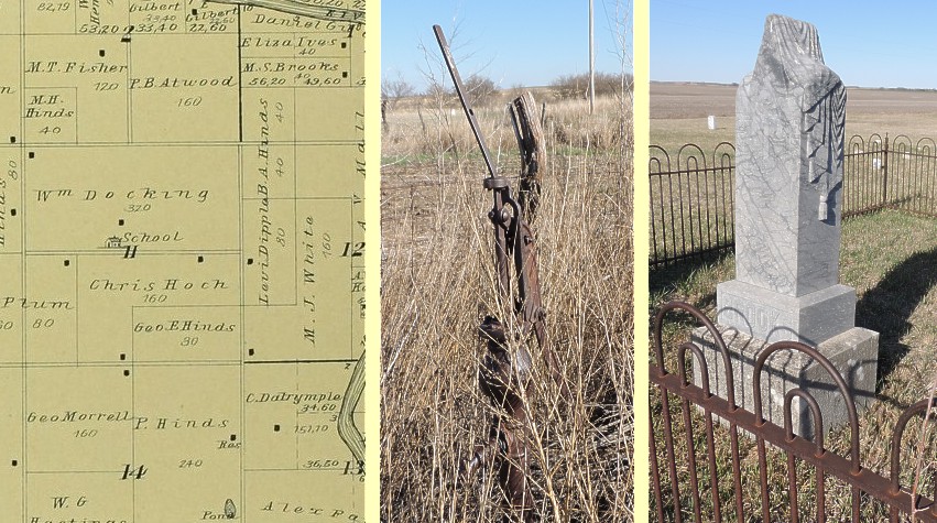
I could see where the road ended in a tee up ahead. Except for an old farmhouse on the left and another about a
half mile to the southeast, the only indication of a community was the green grass of the Gilbert Cemetery.
As we got closer, in the field to the right I saw a small rectangular fenced area no more than a few feet on a
side filled with weeds.
"The school would have sat right there," Art said as he pointed at the patch.
He pulled the van onto 11th Street next to the cemetery. The grounds were about 180 feet on a side. Most of the
headstones were made from local soft limestone. That meant the markings would have vanished long ago. Many were broken.
I was drawn to the cemetery, but Art wanted to see what was in the small fenced area where the school had been. I
decided not to crawl over the barbed-wire fence and walk the muddy field, so I handed him the camera.
"It's a pump - a water pump," Art said as he neared the fenced area.
As he photographed it from various angles, I looked over the fields around us. I felt a twinge of melancholy. The
quietness of the countryside is at once a testimony to success and failure. Clay County is dotted by abandoned homes
and neglected villages of a few blocks in size. When Kansas became a state, the whole county had less than 200
inhabitants. The population increased by a factor of 18 within a decade. By 1890, it was one hundred times larger than
it had been in 1860. But then the decline began. Unless something unforeseen happens, it will soon be home to fewer
than half the number it had at its peak.
The decrease in the number of farmers is even greater. Clay Center, the county seat, has always been, and is today,
by far the largest settlement in the county. In 1890, the village represented less than 15 percent of the county's
citizens. Today, more than 50 percent call Clay Center home.
Yet these figures also document success. The increasing mechanization of agriculture means that fewer and fewer
farmers are needed to complete the farming chores. Every farmer today can handle between three and four times the
amount of land of the farmer of 1890.
This phenomenon is not isolated to Clay County. Of all Kansas counties, almost two-thirds lost population
in the past decade.
After Art returned from the field, we crossed the road and walked the cemetery. A few of the stones could be read in
part. Several were for children less than a year old. Martha Ann Brook's marker even had a small iron fence around
it, although it didn't look as if it had been opened in many decades.
As we headed for the van, the combination of the beautiful spring day and the quietness of the surroundings seemed
to prompt my imagination. No trace remains of the schoolhouse that was closed to youngsters more than a half-century
ago. Yet the old pump installed in 1918 encourages a willing eye to imagine youngsters who are now long gone satisfying
their thirst on warm Kansas days.
For the first 46 years of classes, there was no pump. Water was sometimes fetched from the Republican River a few
miles to the east. Today, parents and pupils alike would think such "field trips" as completely inappropriate. But a
student who had experienced these trips proclaimed that his classmates looked on the task with pleasure, stating it
was better than sitting in the classroom doing their lessons.
So why was I wandering the rural back roads of Kansas? I suppose I was playing hooky from school much as those
water-carrying students were. The university encourages us to reach out to the community around us just as those
students were asked by their teacher to help their classmates. I too enjoyed my day, perhaps as much as they had.
Oh, and there is one more similarity between those students of yesteryear and this teacher of today: after our
momentary escape from our immediate responsibilities, the work must still be completed. But it was worth it. I enjoyed
playing hooky on this fine spring day.